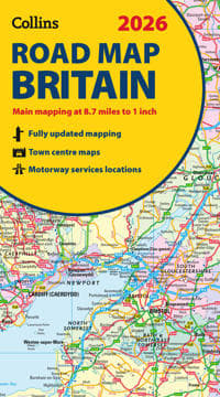
2026 Collins Road Map of Britain
140 kr
140 kr
Tidigare lägsta pris:
155 kr
Ons, 16 jul - mån, 21 jul
Säker betalning
14-dagars öppet köp
Säljs och levereras av
AdlibrisProduktbeskrivning
Full-colour, double-sided road map of Great Britain at a scale of 8.7 miles to 1 inch. Northern England, Scotland and the Isle of Man are on one side with Southern England and Wales on the other.
With its easily identifiable counties and unitary authorities,this map is ideal for business users but it is also perfect for tourists for route planning.
Main features:
- Fully updated
- Counties and local council areas shown in colour
- Clear, detailed road network
- Town and city names, rivers and canals are clearly shown
- 16 city/town centre street plans
- Index to place names
- Mileage chart
- Car ferry routes
- Key in English, French and German
Artikel.nr.
204d3f34-f155-536e-9bfa-b04ac33a4233
2026 Collins Road Map of Britain
140 kr
140 kr
Tidigare lägsta pris:
155 kr
Ons, 16 jul - mån, 21 jul
Säker betalning
14-dagars öppet köp
Säljs och levereras av
AdlibrisLiknande toppsäljare

3-pack rakblad kompatibel med Philips Oneblade Replacement
159 kr

POP MART Labubu The Monsters Exciting Macaron Vinyl Face Blind Box
499 kr
 2023 med MagSafe-fodral (USB-C)")
Apple AirPods Pro (andra generationen) 2023 med MagSafe-fodral (USB-C)
2 698 kr

Trådlös CarPlay adapter 2025 - En smart och modern lösning för din bil
219 kr
Tidigare lägsta pris:
295 kr

POP MART Labubu The Monsters Big Into Energy Series Figures Vinyl Plush Pendant Blind Box
499 kr

Rakapparat med dubbla huvuden 2-i-1 för Kvinnor, IPX7 Vattentät, Bikinitrimmer, Dubbelhuvud, Typ-C Ljusrosa
221 kr

Apple AirPods 4 med aktiv brusreducering
2 060 kr

INF TYPE-C Dubbel SD/TF-kortläsare för snabb dataöverföring 0
79 kr

iPhone Snabbladdare USB-C PD 3.0. 20W Strömadapter + Kabel
117 kr

Trottinette Elektrisk för vuxna AOVOPRO Däck 8,5'' hopfällbar
2 155 kr
Rekommendationer för dig

Fjärrkontroll Philips Smart TV med Netflix – Universell
89 kr
Tidigare lägsta pris:
99 kr

16-pack Premium Mat - Förvaring - Lufttäta Burkar med Lock - Matlådor
299 kr
Tidigare lägsta pris:
349 kr
")
Usb-c till Lightning-kabel (3 m)
59 kr
Tidigare lägsta pris:
79 kr

Vibrationsplattform med rephoppning, träning för hela kroppen Vibrationsträningsplattform massagemaskin för hemmaträning och formning Svart
999 kr
")
Mi Smart Standing Fan 2 (EU)
839 kr
Tidigare lägsta pris:
849 kr

X500 Trådlösa Bluetooth Hörlurar - 30 timmar C4U® ANC ENC BT 5.3
269 kr
Tidigare lägsta pris:
399 kr

UNIQ XL Hollywood Spegel med 15 LED-lampor och touch-funktion - sminkspegel med belysning - hollywoodspegel
749 kr
Tidigare lägsta pris:
795 kr

Apple AirPods 4 Wireless In-ear
1 578 kr

INF Tillbehör för Roborock S5/S6 modeller 7 delar
149 kr

T4 PRO - Hopfällbar elskoter - 8,5 tum - 350W motor - 36V 10,4Ah batteri - Max autonomi 30 km - Bluetooth - Svart
8 917 kr