Children’s Wall Map of the United Kingdom and Ireland
142 kr
142 kr
Tor, 3 jul - ons, 9 jul
Säker betalning
14-dagars öppet köp
Säljs och levereras av
AdlibrisProduktbeskrivning
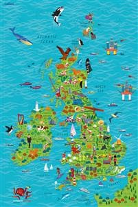
Colourful Illustrated Map of the United Kingdom and Ireland
This highly illustrated, rolled pictorial map is designed to take children on a journey of discovery around the United Kingdom and Ireland.
Stunning illustrations are used to depict themes such as national emblems, customs, food, birds, animals, buildings and sports to help younger readers gain an understanding of peoples around the world.
Illustrated by Steve Evans.
Artikel.nr.
0418cb61-e2d2-4ee2-a843-594ffda9e93b
Children’s Wall Map of the United Kingdom and Ireland
142 kr
142 kr
Tor, 3 jul - ons, 9 jul
Säker betalning
14-dagars öppet köp
Säljs och levereras av
AdlibrisLiknande toppsäljare

168-Pack Tuschpennor med Fodral - Färgpennor Dubbelsidiga Pennor
299 kr
Tidigare lägsta pris:
399 kr

Trådlös CarPlay adapter 2025 - En smart och modern lösning för din bil
219 kr
Tidigare lägsta pris:
295 kr

POP MART Labubu The Monsters Exciting Macaron Vinyl Face Blind Box
499 kr

POP MART Labubu The Monsters Big Into Energy Series Figures Vinyl Plush Pendant Blind Box
499 kr

INF TYPE-C Dubbel SD/TF-kortläsare för snabb dataöverföring 0
79 kr

Apple AirTag 1-pack
336 kr

INF Öronkuddar för Bose QC35 I/II, QC25, QC15, QC 2 AE 2, AE 2i, AE 2w, SoundTrue, SoundLink
79 kr
Tidigare lägsta pris:
99 kr

Elastiskt träningsband till fotboll Gul/Svart
99 kr
 2023 med MagSafe-fodral (USB-C)")
Apple AirPods Pro (andra generationen) 2023 med MagSafe-fodral (USB-C)
2 644 kr

Samsung Galaxy Buds3 Pro - Silver
1 594 kr
Rekommendationer för dig

Bestway Flowclear Solar Pool Cover 3,56m
299 kr
Tidigare lägsta pris:
304 kr

Apple AirPods 4 med aktiv brusreducering
2 060 kr

Apple AirPods 4 Wireless In-ear
1 584 kr

12-pack Oral-B Kompatibla Tandborsthuvuden
89 kr

iPhone Snabbladdare USB-C PD 3.0. 20W Strömadapter + Kabel
117 kr

Apple AirPods 4 Active Noise Cancellation Wireless In-ear
2 089 kr

Apple Iphone 16e 128GB Svart Svart
7 395 kr

Malibu Fast Tanning Bronzing Butter with Beta Carotene 300ml
139 kr

INF Tillbehör för Roborock S5/S6 modeller 7 delar
149 kr
Tidigare lägsta pris:
199 kr

T4 PRO - Hopfällbar elskoter - 8,5 tum - 350W motor - 36V 10,4Ah batteri - Max autonomi 30 km - Bluetooth - Svart
2 379 kr
Tidigare lägsta pris:
2 969 kr