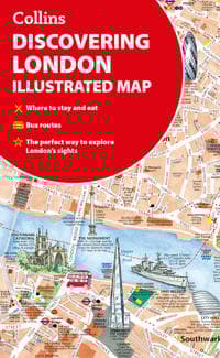
Discovering London Illustrated Map
117 kr
117 kr
Tidigare lägsta pris:
146 kr
Tis, 27 maj - mån, 2 jun
Säker betalning
14-dagars öppet köp
Säljs och levereras av
Adlibris
Produktbeskrivning
A new edition of London’s most original map. This hand-watercoloured map contains individual paintings of all the main sites and landmarks, shop-by-shop street maps, theatres and cinemas, comprehensive travel information and index. This detailed map of Central London is at a scale of 1:8,250 (7.5 inches to 1 mile).
Coverage extends from Regent’s Park in the north to Battersea in the south, and from Kensington in the west to Tower Bridge in the east.
This attractive and fact-filled map would make a lovely souvenir for the visitor to London.
The map features:
- Railway stations, bus routes, London underground map, taxi ranks and car parks
- Shop-by-shop street maps for Oxford Street, Bond Street, Covent Garden, Portobello Road, King’s Road, Brompton Cross, Exmouth Market, Beauchamp Place, St. Christopher’s Place and South Molton Street, Knightsbridge, Jermyn Street and Kensington
- London’s theatres and cinemas
- Places to eat, internet cafés and good places for a picnic
- An inset map of the City of London
- Comprehensive index
- Historical and contemporary anecdotes
Other titles in the series:
- Discovering Edinburgh
- Discovering Glasgow
Artikel.nr.
65b1b171-5b0a-55f8-a891-f9a8da2113df
Discovering London Illustrated Map
117 kr
117 kr
Tidigare lägsta pris:
146 kr
Tis, 27 maj - mån, 2 jun
Säker betalning
14-dagars öppet köp
Säljs och levereras av
Adlibris
Liknande toppsäljare

Apple AirPods 4 Wireless In-ear
1 559 kr
Tidigare lägsta pris:
1 569 kr
 2023 med MagSafe-fodral (USB-C)")
Apple AirPods Pro (andra generationen) 2023 med MagSafe-fodral (USB-C)
2 549 kr

Kompatibel iPhone snabbladdare USB-C strömadapter 20W + 2m Kabel
99 kr
Tidigare lägsta pris:
119 kr

INF Tillbehör för Roborock S5/S6 modeller 7 delar
149 kr
Tidigare lägsta pris:
199 kr

Apple AirTag 4-pack
1 122 kr
Tidigare lägsta pris:
1 136 kr

POP MART Labubu The Monsters Macaron 17 cm
159 kr

Elastiskt träningsband till fotboll - Gul/Svart
114 kr

INF TYPE-C Dubbel SD/TF-kortläsare för snabb dataöverföring 0
79 kr

INF 6-pack trimmerspolar med trimmertråd och lock RYOBI grästrimmer
142 kr
Tidigare lägsta pris:
189 kr

Pool Robot Scooby
4 999 kr
Tidigare lägsta pris:
5 429 kr
Rekommendationer för dig

Laddare till Samsung 25W - Snabbladdare USB-C - Strömadapter+Kabel 1M
99 kr
Tidigare lägsta pris:
119 kr

Fotbollsmål i Metall med Prickskytteduk - 240x170cm
999 kr
Tidigare lägsta pris:
1 299 kr

Röd Vevradio med Solceller, Ficklampa och 2000mAh Powerbank Nödradio, Överlevnad
149 kr
Tidigare lägsta pris:
436 kr

Vattenfontän solcellsdriven 16 cm solcellsfontän vatten fontän utomhus Svart
179 kr

Samsung Galaxy Tab A9+ 11.0 SM-X210 64GB grafit
1 984 kr
")
Sony PlayStation DualSense - White (PS5)
798 kr
Tidigare lägsta pris:
847 kr

Hopfällbar Trädgårdspall med Verktyg / Knäpall - Pall
349 kr
Tidigare lägsta pris:
399 kr

Laddare för iPhone 15 / iPhone 16 + 2M kabel Snabbladdare USB-C till USB-C
99 kr

2025 Ny uppgradering Hundklippare för Hundtassar – Tyst och Effektiv Tasstrimmer med LED-lampa
149 kr

Bright Beauty Vanity Namira - sminkspegel med belysning - hollywoodspegel - make up spegel - vit - dimbar med tre ljuslägen
849 kr
Tidigare lägsta pris:
899 kr