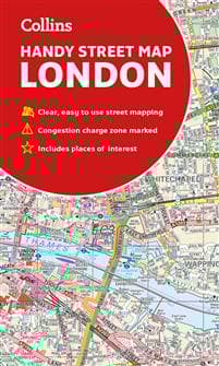
Collins London Handy Street Map
98 kr
98 kr
Tidigare lägsta pris:
105 kr
Fre, 13 jun - tor, 19 jun
Säker betalning
14-dagars öppet köp
Säljs och levereras av
AdlibrisProduktbeskrivning
Clear and easy-to-read map of central London and surrounding area. Contains detailed mapping, presented in a handy compact format.
This attractive map, ideal for both tourists and residents, and fully updated, has an extensive area of coverage and displays a wealth of detail.
This map includes:
• New for this edition: Electric car recharging sites
• Fully classified roads
• Congestion charging zone & T-charge (Ultra Low Emission Zone from April 2019)
• Postal districts and boundaries clearly depicted
• Full indexes to street names (on back of map), place names and places of interest
• Fully updated London underground map conveniently located on the back cover
Covers this area:
Extends from Hampstead in the north to Clapham in the south and from Hammersmith in the west to Greenwich in the east.
Scale: 1:17,500 (3.6 inches to 1 mile)
Artikel.nr.
786422ee-df12-55e6-8db4-e219c0b66380
Collins London Handy Street Map
98 kr
98 kr
Tidigare lägsta pris:
105 kr
Fre, 13 jun - tor, 19 jun
Säker betalning
14-dagars öppet köp
Säljs och levereras av
AdlibrisLiknande toppsäljare

POP MART Labubu The Monsters – Exciting Macaron Blind Box 17 cm Vinylfigur | Samlarobjekt | Designer Toy | Originalprodukt
179 kr
")
1 st POP MART Labubu The Monsters Exciting Macaron Plyschfigur Leksak Blind Box (slumpad färg, 17 cm, 1 pack)
179 kr
")
1 st POP MART Labubu 3.0 Big into Energy Blind Box Figur – The Monsters Vinyl Plysch Hänge 17 cm (slumpad färg, enkel pack)
199 kr

Apple AirPods 4 Active Noise Cancellation Wireless In-ear
2 096 kr
Tidigare lägsta pris:
2 099 kr

2025 Ny uppgradering Hundklippare för Hundtassar – Tyst och Effektiv Tasstrimmer med LED-lampa
149 kr
")
1 st POP MART Labubu 2.0 The Monsters Macaron Blind Box Plyschfigur (slumpad färg, 17 cm, generation 2, 1-pack)
199 kr

Playstation 5 DualSense Controller Midnight Black
639 kr
Tidigare lägsta pris:
679 kr

INF Cocktail set Dubbel shaker 750ml Rostfritt stål Silver 10 delar
289 kr
Tidigare lägsta pris:
385 kr

POP MART Labubu The Monsters Big into Energy 17 cm
199 kr

Laddare för iPhone 15 / iPhone 16 + 2M kabel Snabbladdare USB-C till USB-C
99 kr
Rekommendationer för dig

Pool Robot Scooby
4 999 kr
Tidigare lägsta pris:
5 429 kr

INF TYPE-C Dubbel SD/TF-kortläsare för snabb dataöverföring 0
79 kr

INF Poolfilter för MSPA uppblåsbara pooler FD2089 4-pack
265 kr
Tidigare lägsta pris:
353 kr

UNIQ XL Hollywood Spegel med 15 LED-lampor och touch-funktion - sminkspegel med belysning - hollywoodspegel
795 kr
Tidigare lägsta pris:
895 kr

12-pack Oral-B Kompatibla Tandborsthuvuden
89 kr

iPhone Snabbladdare USB-C PD 3.0. 20W Strömadapter + Kabel
117 kr

Vattenfontän solcellsdriven 16 cm solcellsfontän vatten fontän utomhus Svart
149 kr
Tidigare lägsta pris:
179 kr
")
PlayStation 5 Slim Digital Edition (PS5)
5 219 kr
Tidigare lägsta pris:
6 589 kr

INF Tillbehör för Roborock S5/S6 modeller 7 delar
149 kr
Tidigare lägsta pris:
199 kr

Samsung Galaxy Tab A9+ Wifi 64GB Svart grafit
1 980 kr